National Climate Center: The climate is warm and dry this spring, and it is expected that there may be staged high-temperature heat waves in East China, Central China and Xinjiang this summer.
CCTV News:According to WeChat official account, the National Climate Center, in the spring of 2023, the national average temperature was generally high, the seventh highest in the same period in history, but the temperature fluctuated obviously during the season; The national precipitation is generally less, which is the least in the same period since 2012, and the spatial difference is large. The precipitation in the eastern part of North China and Northwest China is more, and the precipitation in Southwest China, South China and Northeast China is less. The daily maximum temperature of 184 national meteorological stations in China has reached the standard of extreme events, of which 77 stations have reached or exceeded the historical extreme value; The daily precipitation at 31 stations exceeded the historical maximum in spring, and at 3 stations in Shaowu, Fujian, it exceeded the historical maximum. The flood season in South China and the onset of summer monsoon in South China Sea are both early. In spring, there were 10 heavy rains in China, including 3 heavy rains; Severe drought in winter and spring has occurred in Yunnan this year, which is not good for the growth of spring-sown crops; There were 12 strong convective weather in spring, which was extremely local. There are 13 sandstorm weather processes affecting China, more than the same period in 2000-2022.
1. National weather and climate characteristics in spring.
The national average temperature is on the high side, and the temperature fluctuates obviously during the season.In the spring of 2023 (March-May), the national average temperature was 11.5℃, which was 0.6℃ higher than the normal period (10.9℃) and the seventh highest in the historical period since 1961 (Figure 1). However, the temperature fluctuates obviously during the season.
The temperature in early March, mid-March and mid-April was abnormally high, exceeding 1.5℃, and the average temperature in early March and mid-April was the highest in the same period in history. The temperature was lower than 1℃ in late April and early May, and the average temperature in late April was the fifth lowest in the same period in history.
In spring, the temperature in China is generally higher in central and eastern China and lower in western China, with the temperature in northeast China and eastern Inner Mongolia, eastern North China, most of eastern China, eastern and southern Central China, and eastern Southwest China being 1 ~ 2℃ higher (Figure 2). The average temperature in Jiangsu and Yunnan is the highest since 1961, followed by Liaoning, Shandong, Shanghai and Guizhou, and the third highest in Heilongjiang, Beijing, Hebei, Anhui, Zhejiang, Jiangxi and Hunan.
During the season, the daily maximum temperature of 184 national meteorological stations in Southwest China and South China (accounting for 7.6% of the total number of national stations) reached the standard of extreme events, among which 77 stations in Qiaojia, Yunnan (44.4℃, May 31st) and Yuanmou (43℃, May 31st) reached or exceeded the historical extreme value (Figure 3). The daily cooling range of 135 stations in Inner Mongolia, North China, the eastern part of Northwest China and Central China reached the standard of extreme events, among which the daily cooling range of 26 stations in Fuhe, Inner Mongolia (16.5℃, April 11th) and Lintong, Shaanxi (15.5℃, April 21st) exceeded the historical extreme value (Figure 4).
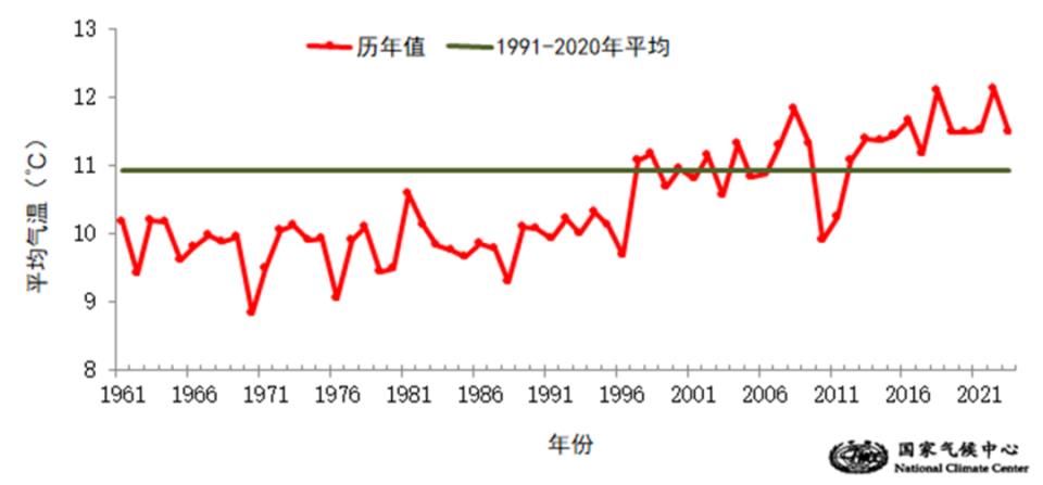
Figure 1 Annual changes of national average temperature in spring from 1961 to 2023 (unit:℃)
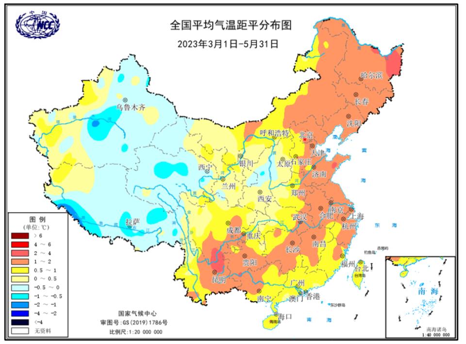
Fig. 2 Distribution map of national average temperature anomaly in spring of 2023 (unit:℃)
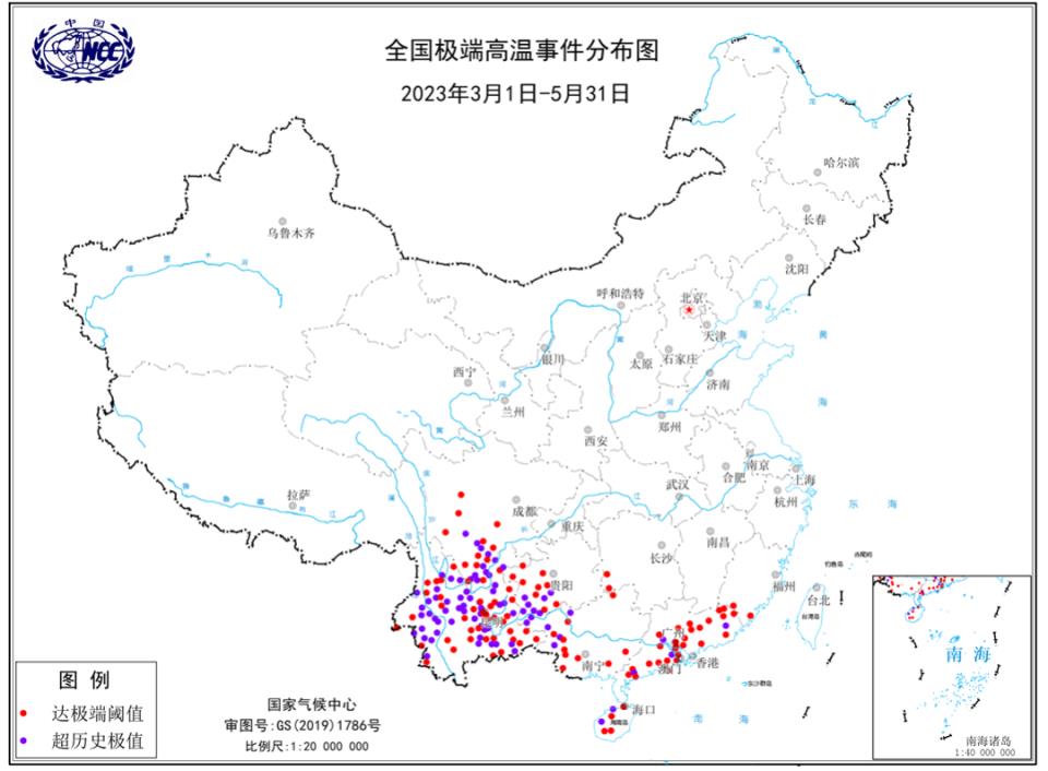
Fig. 3 Distribution map of extreme high temperature events in spring of 2023.
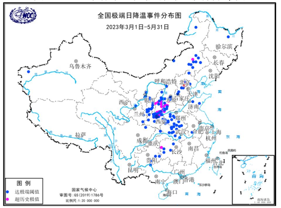
Fig. 4 Distribution map of extreme daily cooling events in spring of 2023.
The national precipitation is generally less, with large spatial differences, and the precipitation in North China and the eastern part of Northwest China is more.In spring, the national average precipitation was 132.2 mm, 8.1% less than normal, and the lowest since 2012 (Figure 5). The precipitation in most parts of North China, northwestern East China, northern Central China, eastern Northwest China, central and southern Qinghai, northern Tibet and southern Xinjiang is 20% to 2 times higher. Rainfall in most other parts of the country is relatively low, with 50-80% less in southeastern Inner Mongolia, central Jilin, southwestern Sichuan, eastern Yunnan, southwestern Guizhou, western Guangxi, western Gansu, western Tibet and western Xinjiang, and more than 80% less in local areas (Figure 6). The precipitation in Yunnan is the second least in the historical period since 1961, and that in Zhejiang is the third least in the historical period. The precipitation in Shanxi is the highest in the same period in history.
In spring, the daily precipitation of 118 national weather stations in China exceeded the historical maximum in that month, among which the daily precipitation of 31 stations exceeded the historical maximum in spring, and the daily precipitation of Shaowu, Fujian (275.1 mm, May 6), Yihuang, Jiangxi (258.1 mm, May 6) and Xiuwen, Guizhou (228.3 mm, May 26) exceeded the historical maximum.
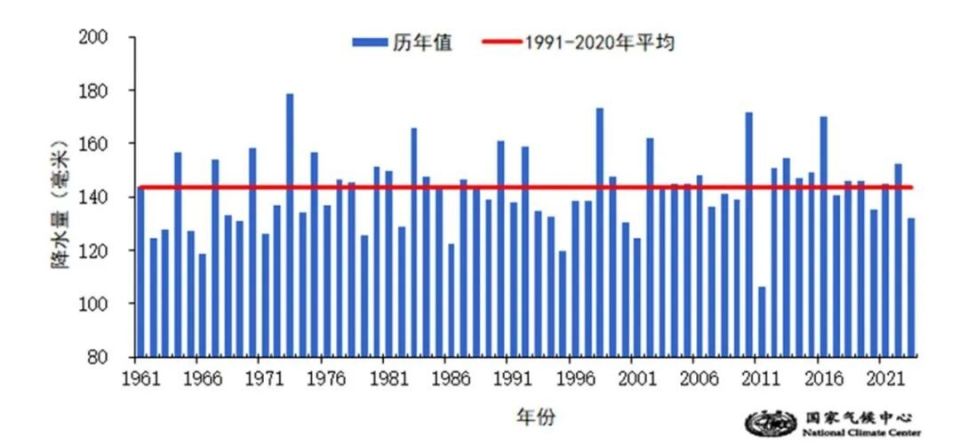
Fig. 5 Annual changes of national average precipitation from 1961 to 2023 (unit: mm)
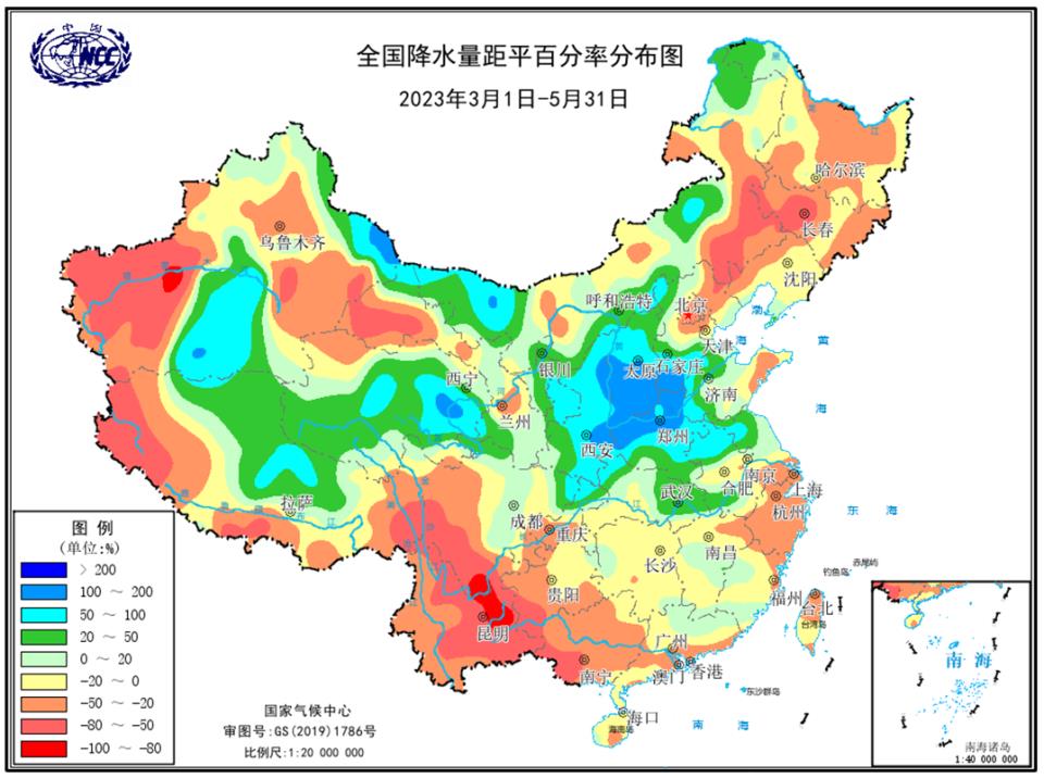
Fig. 6 Distribution map of national precipitation anomaly percentage in spring of 2023 (unit:%)
2. Main weather and climate events in spring
The flood season in South China and the onset of summer monsoon in South China Sea are both early.The first flood season in South China in 2023 began in Guangdong on March 26th, 14 days earlier than normal (April 9th). Since the flood season (from March 26th to May 31st), the average precipitation in South China is 311.7mm, which is 22.9% less than the normal period, and the eighth least in the same period in history. The South China Sea summer monsoon broke out in the third period of May (specifically, May 14th), and the date of the outbreak was one period earlier than normal (May 4th).
Ten rainstorm processes have affected China, including three heavy rainstorms.In spring, there were 10 heavy rains in China, and some areas suffered from heavy rains and floods. Among them, the three rainstorm processes on March 20-25, April 1-5 and May 2-7 were strong, and the rainstorm processes on May 2-7, May 20-22 and May 25-28 had great influence. On May 2-7, the cumulative precipitation in most parts of Jianghuai, western and eastern Jianghan, most parts of Jiangxi, most parts of Fujian, and western Hunan was 50-100mm, with some exceeding 100mm. The daily rainfall of 20 national meteorological observatories exceeded the historical extreme in May. The local torrential rains in Fuzhou, Ji ‘an and Yichun, Jiangxi Province, and the riverbank in Xiajiang section of Qingfeng River Bank in Licun Town, fengcheng city, Yichun City burst, resulting in the flooding of several downstream villages. On May 20-22, the rainstorm process in southern China was strong. From 5: 00 pm to 8: 00 pm on the 22nd, the precipitation in three hours reached 300.1 mm, and the hourly rainfall intensity reached 160.6 mm, breaking the historical record of hourly rainfall intensity in downtown Guilin. On May 25-28, a strong rainstorm occurred from the southwest to Jianghuai and Huanghuai. Due to continuous rainfall, the summer wheat harvest in Huanghuai and other places and railway transportation in some sections were affected.
Yunnan suffers from drought in winter and spring.In the first half of March, the temperature in East China, South China and South China rose rapidly, the precipitation was less than 80% compared with the normal period, and the meteorological drought emerged and developed rapidly. On March 16, the affected area of moderate and above meteorological drought reached the maximum. After that, due to the influence of precipitation, the drought in most of the above areas was alleviated at the end of March, and only moderate and above meteorological drought existed in Yunnan and Shandong. In April, due to the influence of high temperature and little rain, the meteorological drought in Yunnan, southwest Sichuan and southern Guizhou continued or developed. On May 9th, the areas of moderate drought and above and extreme drought in Yunnan Province reached the largest, accounting for 354,000 square kilometers and 176,000 square kilometers respectively. From 13 to 16, there was an obvious precipitation process in the west of southwest China, and the meteorological drought in western Yunnan and western Sichuan was alleviated. In the latter part of the year, the precipitation in most parts of southwest China is obviously less and the temperature is higher, and the meteorological drought in eastern Yunnan, western and southeastern Sichuan, western and southern Guizhou, and central and western Guangxi has developed again, with moderate to severe meteorological drought and extreme drought in some areas (Figure 7). Since the beginning of this year, severe drought has occurred in Yunnan in winter and spring, in which the average precipitation in spring is 86.8 mm, which is 51.1% less than the normal period, the least in the same period since 1961, and the average meteorological drought days are 64.9 days, the second most in the same period since 1961.
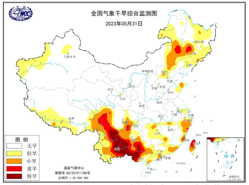
Figure 7 Comprehensive Monitoring of Meteorological Drought in China on May 31, 2023
12 strong convective weather affected our country, with strong local extremes.In spring, there were 12 strong convective weather in China. One in March, six in April and five in May. On April 15th, strong squall winds occurred in Shandong, Jiangsu and other places. The instantaneous maximum wind force in many places in northern and eastern Jiangsu reached 12 ~ 13 (the maximum was 41.9 m/s), and two tornadoes appeared successively in Dezhou and Linyi, Shandong, breaking the earliest record of tornadoes in this province. On the afternoon of May 12th, a regional strong thunderstorm and gale occurred in Beijing-Tianjin-Hebei region, with the strongest winds in the northeast and central and eastern parts of Hebei, with the local level reaching 12, and hail weather occurred in Baoding. On the 16 th, regional thunderstorms and strong winds occurred in central and eastern Jilin, central and western Liaoning, western and northeastern Hebei; Northeast Hebei, northwest Liaoning, eastern Jilin and other places have the strongest winds, with local grades of 11 ~ 12, which have a negative impact on grain summer harvest. On May 20-23, a large-scale strong convective process affected most parts of China from north to south. The intensity of heavy precipitation in Guangxi, Guangdong and other places exceeded 100 mm/h, and some cities experienced waterlogging.
Thirteen dust storms have affected China, more than the same period in 2000-2022.In spring, there were 13 sandstorm weather processes affecting China, 2.5 times more than the same period in 2000-2022 and 4.5 times more than the same period in the last decade (2013-2022). Among them, April 9-13, April 27-29 and May 19-22 were sandstorms, and March 19-24 and April 18-21 were strong sandstorms, which had a great impact on air quality, transportation and human health.
Recently, the National Climate Center organized relevant units to have a rolling discussion on the climate forecast trend this summer, and formed the following opinions:
It is estimated that this summer (June to August), the precipitation in China will be in two rainy zones in the north and south, and the precipitation in eastern Heilongjiang, southern Zhejiang, Fujian, southwestern Jiangxi, Guangdong, eastern Guangxi, Hainan and central and western Yunnan will be 20% to 50% more, so it is more likely that extreme heavy precipitation will occur locally. The precipitation in the middle reaches of the Yangtze River is 20-50% less. Regional meteorological drought may occur in the eastern part of southwest China and central China; The geological disasters of mountain torrents in the south of southwest China are biased; In summer, the temperature in most parts of the country is close to normal to high, and the temperature in East China, Central China and Xinjiang is high (the highest daily temperature ≥ 35℃) days are more than normal, and there may be staged high temperature heat waves. In summer, the number of tropical cyclones generated in the northwest Pacific and South China Sea is close to normal, and the number of tropical cyclones landing in China is close to normal. The tropical cyclone activity path is mainly westbound and northwest, which mainly affects the coastal areas of South China and East China.